where I stole it, temporary placeholder image until I can come up with something
more appropriate and legal. Cool picture, though.
| 6. Yearly Calendar Predictor |
|
| Not Chaco Canyon but maybe the Mayans.
Image credit missing from the site where I stole it, temporary placeholder image until I can come up with something more appropriate and legal. Cool picture, though. |
Here is this activity as published on the Astronomical League observing program page:
"A trip to an ancient site like Chaco Canyon National Historic Park in New Mexico is a very rewarding experience. Scientists and Anthropologists have discovered the ancient inhabitants created predictors for the solstices and equinox by noting when the sun would rise or set behind features on the horizon. One of the most famous at Chaco Canyon is Anasazi Sun Dagger. Chaco Canyon has other features like doors, windows, and hallways that align with the Sun at certain times during the year. Chaco Canyon isn’t unique. In Great Britain places like Stonehenge and Avebury, or Ireland’s Newgrange and Egypt’s pyramids and Nabta Playa show alignments with astronomical objects.
Your task is to find a place where you live where on the winter or summer solstice you can view the rising or setting Sun behind an object on the horizon (how might your astrolabe be able to help with this activity?). Take a picture that shows the event.
While it would take much too long for the benefit, the same method could be used to find the length of a year. Here you would count the number of days until the sun came up behind the object again. If you keep observing you’ll note that after a few years your object won’t exactly be in front of the sun when it rises or sets. This is because a year is really more than 365 whole days long and that a leap-year correction needs to be made. Ancient societies had centuries to work this out and develop their calendars. Investigate ancient calendar systems some night when you can’t get out to observe and nothing is on TV."
Utilizing conveniently located pre-existing pyramids, here's my approach to the activity:
December 29, 2018 -- Aurorahenge: Yearly
Calendar Predictor
The program asks you to find a location where you can
view either the rising or setting sun on Winter or Summer Solstice. Find a spot
where the sun lines up with a landmark as it crosses the horizon. Take a picture
of the event.
Due to holiday obligations and uncooperative weather,
I was unable to complete this task until December 29, eight days past Winter
Solstice. I did manage to use my freshly minted quadrant to get a solar
elevation reading a day after Solstice. I am doing many of my observations in my
back yard, but I do not have an unobstructed views of the horizon from my yard.
I know of several locations within a short drive where
I have a good view of the Denver front range of the Rocky Mountains. The
mountains would make a pretty good landmark opportunities, but the ridge of
peaks on the horizon are about 70 miles away and often partially obscured by
haze. I found a great location a short walk from my house: the City of Aurora
Olympic Neighborhood Park.
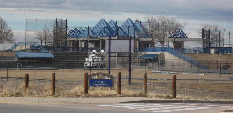
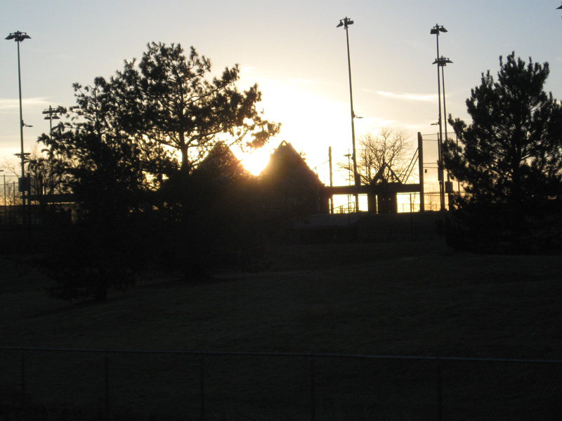
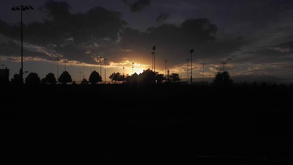
The park features four baseball diamonds, essentially four quadrants of a circle, clustered around a central point. At the center is a building housing concessions, restrooms and other facilities. I'm not sure if this is what the designer had in mind, but the highly peaked roofs of the structure are reminiscent of a stylized mountain range. Perfect for noting the location of the setting sun.
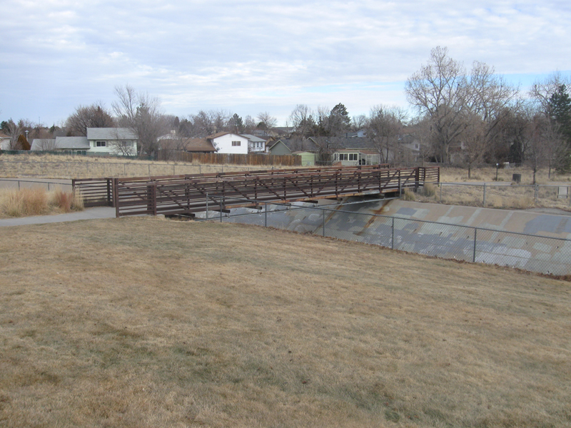
About 200 yards northeast of the simulated mountain range there is an iron pedestrian bridge over a drainage ditch. Standing on the north end of the bridge, the baseball building lines up with the setting Sun.
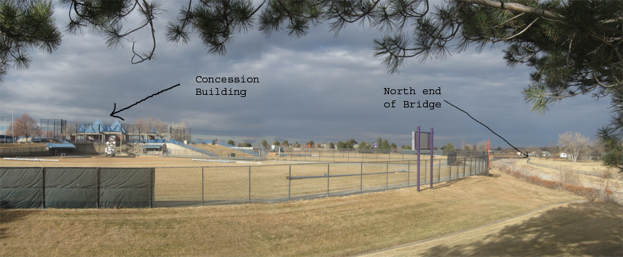
This panoramic view gives you an idea of the scale of the setup.
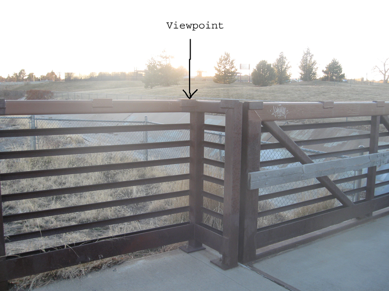
I chose the exact viewpoint at the time of sunset. I chose a point that gave me a good view of the setting sun against the peaks of the concession building. The exact spot along the bridge rail is easy to locate. It is on the outer corner of a little flange where the bridge and rail widen at the northeast end.
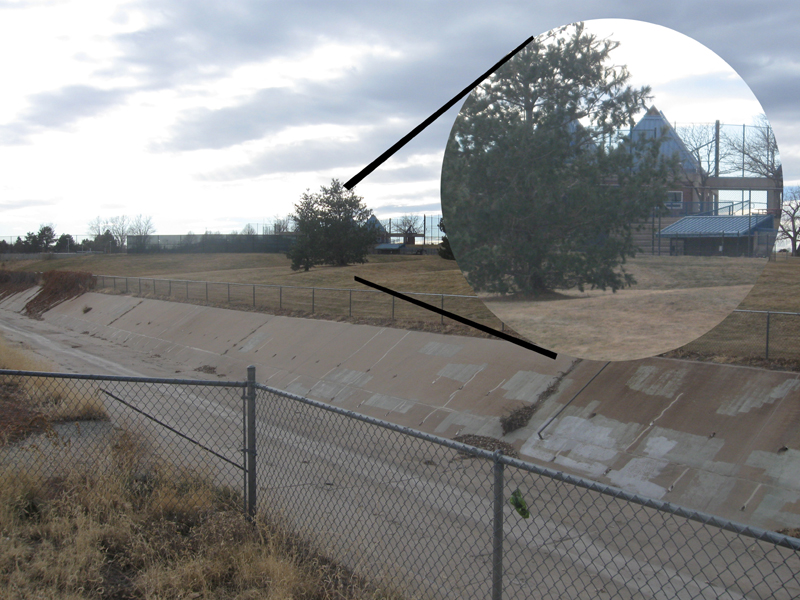
Here is a view of the perspective taken a few days later and a bit earlier in the afternoon. The circular inset is an enlarged view of the concession building. Without the background glare of the sun, you can make out the details of the roofline. (In spite of the inconveniently placed evergreen tree). The four main peaks of the building are happily arranged along a NE/SW axis, so from this perspective it looks like only two peaks forming a nice notch.
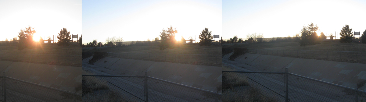
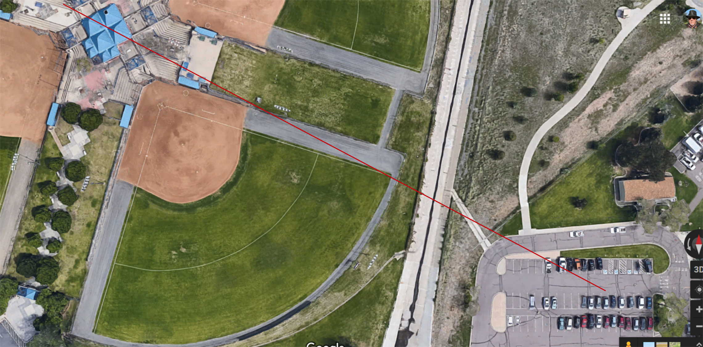
This succession of three images taken at sunset on 12-29-2018 records the Sun settling into the notch formed by the building roofline. I predict that if I return to this exact spot in one year, the sun will set in the same spot. Now I will attempt to predict where I will have to stand on the bridge to witness the Sun set on the same landmark on the actual Solstice of 2019. To do this, I will have to resort to some high power resources: Google Maps satellite view, the Stellarium planetarium program, Inkscape graphic editing program, and a little good old fashioned trigonometry.
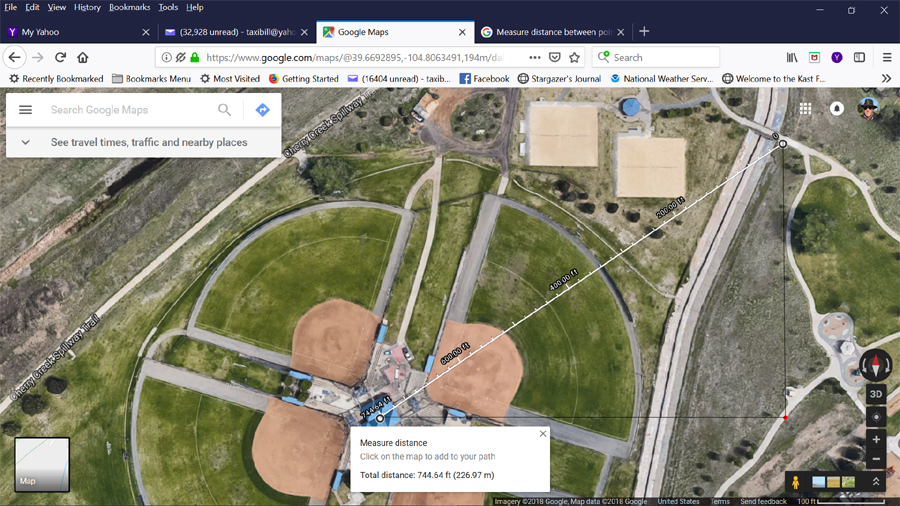
I opened Google Maps on my
computer and located Olympic Park and switched to satellite view. The concession
building and the pedestrian bridge were both clearly visible. I marked them on
the map and used the distance tool to determine the distance between them--744
feet, not too far off from my estimate of 200 yards.
I took a screenshot of the map and downloaded it to
Inkscape graphics editor. I overlaid a grid and laid out a right triangle with
the line of sight being the hypotenuse and the adjacent and opposite legs
oriented east-west and north-south respectively. At this point I am taking a
leap of faith that the Google maps are aligned accurately with the NS/EW
geographic axes. The point of this exercise is to calculate the azimuth angle of
the setting sun from my viewpoint and compare it to the value generated by
Stellarium.
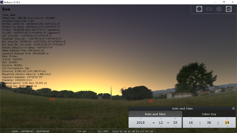
At sunset on 12-29-2018 at
16:38:14 MST for my location, Stellarium shows the sun setting at azimuth 239
degrees 48 minutes. The moment of sunset can be derived by first freezing the
clock in Stellarium then adjusting the time setting until the apparent altitude
approaches zero. The azimuth that I calculated from the map is 231.45 degrees,
an error of 3.5% from the predicted value. That doesn't sound too
bad, unless you're trying to navigate across the ocean where an 8 degree error
puts you 500 miles off course.
The sun actually dipped into the notch a few minutes
earlier than the Stellarium prediction. This is because I was not looking plumb
horizontally out at the horizon, but up a hill. And the sun was setting behind a
building higher than that. So I recalculated the azimuth for
the sun crossing what I percieved as the horizon.
I entered the precise geographic coordinates of the
concession building and the observation point into the tool
www.whatismyelevation.com and found that there was an elevation difference of 31
feet between the two points. I estimate another 20 feet for the height of the
"notch" above the base of the building. I added these two figures, came up with
51 feet and rounded it to 50. I already knew the distance between the points,
approximately 745 feet. This was enough information to calculate the angle of my
line of sight above horizontal: 3.84 degrees.
I went back to Stellarium and ran the clock backwards
until the altitude of the sun was 3.84 degrees above the horizon (it is zero at
sunset). The sun does not go straight down perpendicular to the horizon, but at
an angle. As the altitude changes, so does the azimuth.
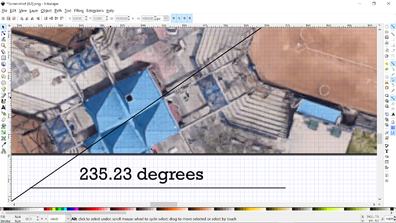
I adjusted the Stellarium time until the solar
altitude was 3.84 degrees above the horizon and read the azimuth as 235.23
degrees. (I used another online program to convert the Stellarium
degree/minute/second format to decimal degrees. Decimal works better in the
Inkscape graphic editor.) --ed. note 12/23/21
I was still pretty new to Stellarium at that time. It didn't take me long
to discover the tools setting that adjusts for either decimal degrees or
degrees/minutes/seconds.
The corrected predicted value of 235.23 degrees varies
from the observed value of 231.45 by only 1.6%. Better than the original 3.5%
error, but still pretty significant. I think the experimental error could be
improved by getting a more accurate value for the elevation difference between
the roof notch and the bridge observation point.
I then set Stellarium time back to time of apparent
sunset (3.84 degrees above the horizon) on 12/21/2018, the day of the Solstice.
The azimuth of the Sun at that time now reads 235.23 degrees.
I constructed an angle of this value in the graphics editor and overlaid it so the line intersected the notch in the concession building roofline.
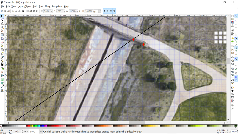
Here is a screenshot of the
same line extended to the pedestrian bridge. The red marker to the right
indicates the location of my sunset observation on 12/29/18. The marker to the
left (intersected by the notch view line) is the predicted viewing location for
the Winter Solstice next year. I shall return to the bridge at that time and
test my prediction. December 22, 2019. Mark your calendar.
I may also use this method to predict a viewing
location for the Summer Solstice. If I do, it will be posted as a new journal
entry.
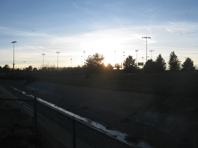
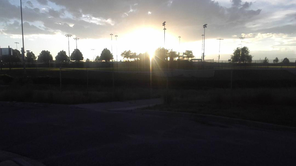
Winter Solstice December 21, 2019
Although December 22 is marked on the calendar as the first day of Winter, Solstice actually occurs on December 22 at 04:19 UT. For the Mountain Standard Time zone, this translates to December 21 2019 at 21:19. The closest Solstice sunset occurs at 16:38 MST, 4 hours and 41 minutes before Solstice. Because my landmark is elevated nearly 4o above the true horizon, the Sun slips into The Notch about a quarter hour before actually setting.
I returned to my predicted benchmark at Aurorahenge before sunset on December 22. I then took the following picture showing the Sun settling into the notch at 16:17 MST:
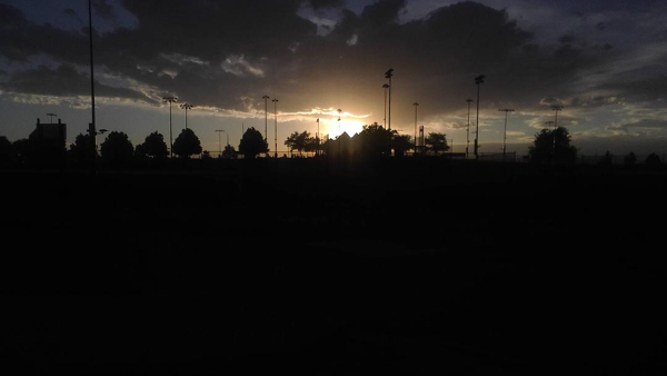
Winter Solstice December 21, 2021
I returned once again on the first day of Winter in 2021. Solstice occured at 8:59 am MST on this date. The next photograph was taken at 4:17 pm MST, 7 hours and 18 minutes past Solstice. The sky was 99% clear with a few high cirrus clouds over the mountains on the western horizon.
Summer Solstice June 21 2019 Sunset
I used the hand held quadrant to measure the angle of the "notch" above the horizon. I measured 3.5o. I then consulted Stellarium to determine when the time that the setting sun would cross that elevation, and the sun's azimuth. I came up with an azimuth of 301.1o at 20:04:03 Mountain Daylight Time.
Next I used my downloaded Google Maps aerial image of Olympic Park. I loaded this image into Inkscape and created a line at azimuth 301.1o intersecting the notch. This line crossed the drainage ditch and ran across the Yale Elementary School parking lot.
The weather did not cooperate with this observation. It was too cloudy at sunset on June 21 (Solstice) and on the following two days. On June 24 it finally cleared up enough to make an observation. The following set of photos were taken from the northwest corner of the parking lot on June 24 at 20:10 MDT. Even though it's a few days past Solstice, the sun still settles nicely into the notch created by the peaked building roofs.
--Astronomy before the telescope index page--