| 1. Direction - Find true north without a compass |
|
Here is this activity as published on the Astronomical League observing program page:
"1. Direction - Find true north without a compass: A
number of the other activities will need true north so we’ll deal with finding
directions first. As astronomers we have identified the
North Star (Polaris), so make a sketch of finding north using the familiar
constellations. This can be done using any of these techniques (Why not try them
all?).
• Using the “Pointer Stars” at the end of the bowl of the Big Dipper.
• Using the “cleaner” triangle of Cassiopeia.
• Go from the center of Orion’s Belt through his head (Meissa).
• Using the Summer Triangle by starting at Altair and moving through the open
end of the triangle (closer to Deneb).
• The shadow (dip) method works well in the daytime and was the method used in
the previously mention movie. Find true north and put down markers that you can
refer to for future activities. The markers will help you locate the meridian
for other activities below. Place a compass so that it can be seen with the
markers and take a picture. Finally measure the magnetic declination (difference
between magnetic and true north) using your apparatus and your location. If you
can, repeat the activity at a second location a few hours from where you live so
you can see that location offsets really do matter."
Follow the North Star
Finding true north in the northern hemisphere is done by finding the North Star (Polaris, α Ursa Minoris). Locate Polaris and face it square on. You will be facing north. At a declination of 89o 21' Polaris is about 2/3 of a degree away from the celestial north pole. In the course of a 24 hour day Polaris circumscribes a circle a little more than a degree in diameter around the celestial north pole. So the North Star is not spot-on north except when it transits the meridian and once again 12 hours later, but it is never more than a degree away from true north.
It should also be noted that Polaris is not quite constant as the north star. Just as a toy top or gyroscope slowly wobbles around its spinning axis, the Earth also wobbles. This is known a axial precession. The result is that over time, the position of the celestial north pole--true north--changes with respect to the position of the stars. In 14,000 years Vega will be the closest bright star to the pole. In 27,000 years the cycle will complete returning Polaris to the title of North Star.
But for now and in recent history, Polaris serves well as an indicator or true north. Shining at a magnitude of 2.1, Polaris is the brightest star in the immediate area, so there's no confusion when you find it. It is bright enough to be seen even under light polluted suburban skies.
Pointer Stars
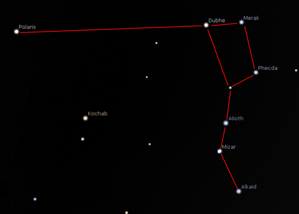
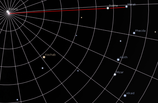
The most familiar method of locating Polaris is by following the "pointer stars" of the Big Dipper asterism of the constellation Ursa Major. Follow an imaginary line from the two stars at the end of the dipper to Polaris.
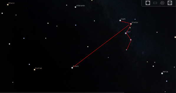
While this method works quite well most of the time, during the late Autumn and Winter months the dipper lies low to the horizon and can be obscured by geography and vegetation, as well as atmospheric haze on the horizon. At this time of the year, Cassiopeia is high in the sky and makes a suitable substitute. Three stars of the constellation form a nearly perfect equilateral triangle. Visualize these three stars as an arrowhead, and the shaft of the arrow leads back to Polaris.
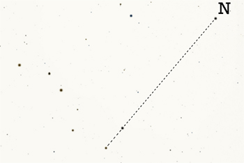
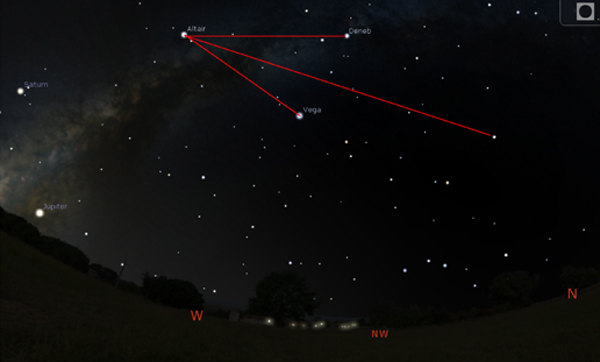
I have used the first two methods of finding Polaris many time over the years. Using the "Summer Triangle" asterism was new to me, and I tried it on January 4, 2020 while attending open house at Denver's Chamberlin Observatory. In the early evening the Summer Triangle is still visible, even under light polluted skies just a few miles from downtown Denver. The method is similar to the one used for Cassiopeia, with the Summer Triangle forming an imaginary arrowhead. Once again, the shaft of the arrow leads back to Polaris.
The other suggested method which I also tried for the first time on January 4 was using two stars in the Orion constellation as pointers. While Alnilam and Meissa line up nicely with Polaris, it's a 90o span halfway across the sky to the North Star. I find this to be somewhat impractical.
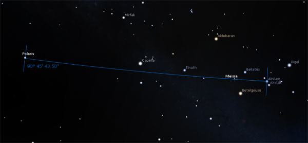
The trick with pointer stars is to use two stars with very close right ascensions. This means that the two stars line up nicely close to the same meridian line. For instance, in the case of the Big Dipper pointers, Dubhe has a right ascension of 11:04:58 and Marak's RA is 11:03:03, a difference of 1'55". Even as the stars (apparently) rotate about the celestial pole, they maintain the same orientation pointing at Polaris. Alnilam (RA 5:37:15) and Meissa (RA 5:36:16) in Orion are only about 1 arc minute apart in RA and make an ideal pointer pair, but for their extreme southern declination.
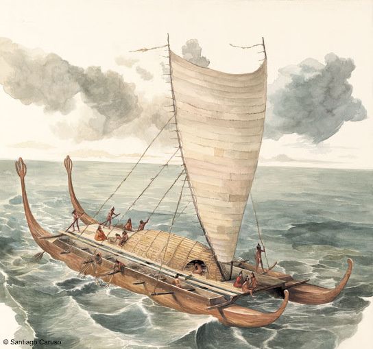
Finding True South in the Southern Hemisphere
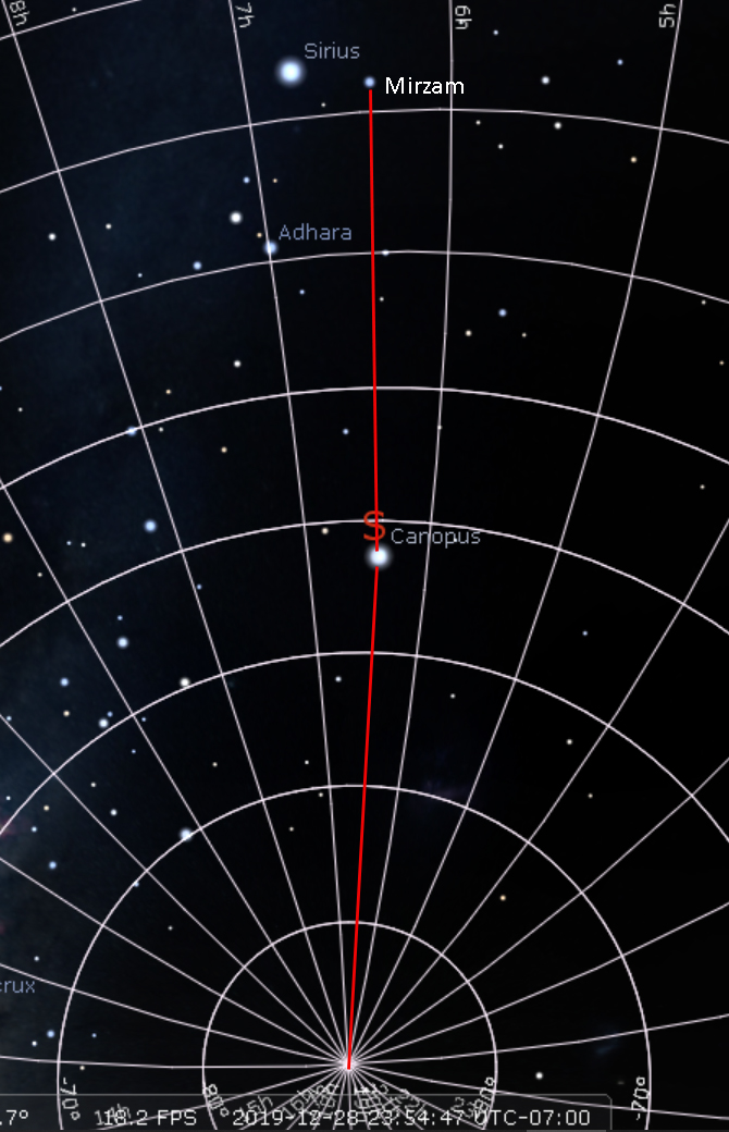
The Polynesian navigators were renowned for their ability to locate tiny islands across the vast tracts of the South Pacific. They used a mixture of intimate knowledge of currents and weather patterns along with stellar observations to guide them along the way. South of the equator Polaris dips below the northern horizon. There is no bright star near the celestial south pole, so there is no "South Star" analogous to Polaris. But there is a brilliant pair of pointer stars to point you in the right direction. Mirzam (β Canis Majoris) magnitude 1.95 and Canopus (α Carinae) magnitude -0.65 lay at RA 6:23:36 and 6:24:24 respectively. Separated by less than an arc minute of RA, they point the way to the south celestial pole. From Mirzam, Canopus is roughly half the distance to the south celestial pole.
December 21, 2018 -- The Shadow (Dip) Method
I was armed with the prior knowledge that on this day,
the day of the Winter Solstice, that the Sun would transit the meridian exactly
at noon. (ed. note: boy was I wrong about that statement). I was also armed with
a fairly accurate wristwatch synchronized within one second to WWV atomic clock
time. At noon today the sun would cast a shadow along a true north-south line.
(ed. note: the actual significance of the Winter Solstice is that the shadow
cast would be the longest shadow of the year. The sun is as low to the horizon
as it gets. It is the time of the shortest day and the longest night. This
activity can be performed on any sunny day as long as the time of local solar
noon is known. The fact that it was Solstice day had no bearing on the
performance of this task, other than the fact that the Sun casts a conveniently
long shadow.)
I needed a gnomon, an upright rod or pole to cast a
shadow. We have a canopied gazebo in the back yard. The canopy is taken down for
the Winter, but the frame stays up year round.
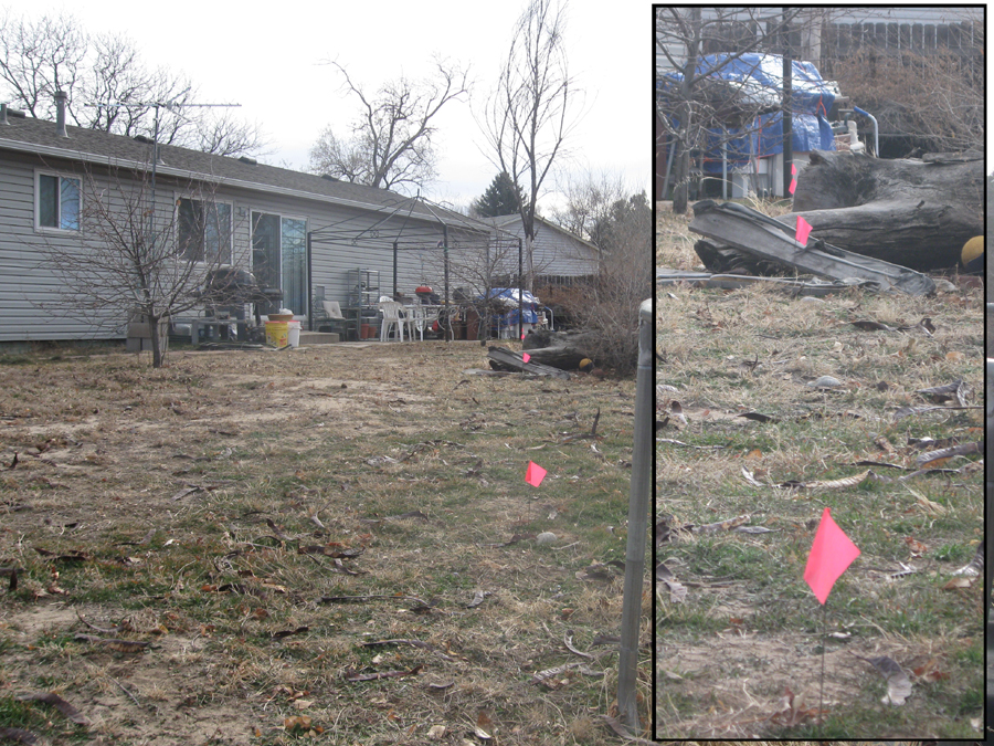
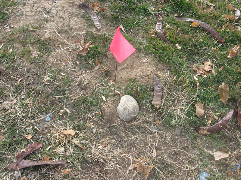
At noon I placed rocks on the ground at two points
along the center of the shadow cast by one of the canopy uprights. I marked the
rock positions with utility marker flags. These two rocks are roughly 8' 5"
apart. The rocks are round river rock commonly used in landscaping, about 3-4"
in diameter. I screwed the rocks into the soft sandy soil with the heel of my
foot so that they would not be disturbed by the lawn mower.
I then went out toward the
corner of the yard, what I call my "dark corner", because this corner has the
least interference at night from street lighting. I placed two more rocks along
the north-south line about 35' and 70' away from the canopy upright. I aligned
these rocks by eye with the two marker flags planted at the canopy upright and
the noontime shadow marker.
So on this the first day of Winter, I have constructed
my own personal Stonehenge marking a north-south line across my back yard. On
the first clear night I will go out and check how my markers line up with
Polaris, the north pole star.

Here's my Old School GPS instrument. The rosette is set to 0o and the compass is aligned with the North-South line which I laid out. The compass needle reads 11o, which is pretty close to the magnetic declination for Denver.
Procedural flaws and suggested improvements:
The upright of the canopy did not look quite right, so
I checked it with a carpenter's spirit level. Sure enough, the upright is maybe
two degrees out of plumb. In addition, the 3" square metal post casts a broad
shadow. The shadow nearly matched the diameter of the marker rocks, so I simply
centered the rocks in the shadow.
I plan to repeat this procedure with these changes:
Rather than using the shadow cast by the canopy post, I will suspend a weight
from the frame by means of a stout cord. The nylon cord I will use is about 1/4"
in diameter, broad enough to cast an observable shadow yet far more precise than
the shadow of the post. Suspended like a pendulum, the nylon cord gnomon will be
true perpendicular.
If I can enlist the aid of an assistant, I would like
to mark the noontime shadow by stretching a long cord precisely along the shadow
cast by the gnomon precisely at solar noon. This cord can then be secured to the
ground and used to establish more permanent stone markers.
An yes, solar noon. I marked the north-south line at
noon today, 12:00 Mountain Standard Time. Close but no cookie. By convention
local noon (ed. note: wrong again, Bubba. Local
noon is determined by your longitude. Adding or subtracting the Equation
of Time correction to local noon gives you Solar noon) is when the Sun
transits the center of the Time Zone that's actually
civil 'clock time' noon (allow
correction for Daylight Savings Time), so my shadow was marked about seven
minutes late. According to Stellarium (planetarium software) solar noon / Sun
transit occurred at 11:53 PM. This transit time changes daily due to the
equation of time. I will conduct a second procedure using a more accurate
transit time.
I kind of feel like I'm cheating already. This program
is Astronomy Before the Telescope. It is true that I am not using a telescope,
but I have access to accurate time keeping and almanac software. I have prior
rudimentary and sometimes inaccurate --ed. knowledge of the analemmatic change of position of the sun and of the equation
of time.
Never mind that, though. My goal is to establish a
true north-south line across my property without the use of a compass (or GPS!).
This step is a necessary antecedent to many of the program activities. I will
use whatever means and information that I have at my disposal short of using an
actual telescope (or compass). I will use rocks. I will use stout cord.
In March of 2019 I checked my stone markers at Solar transit per Stellarium predicition. I used a plumb bob suspended on a 1/4" nylon cord. The stones I had laid out at five points across the yard were quite accurate.
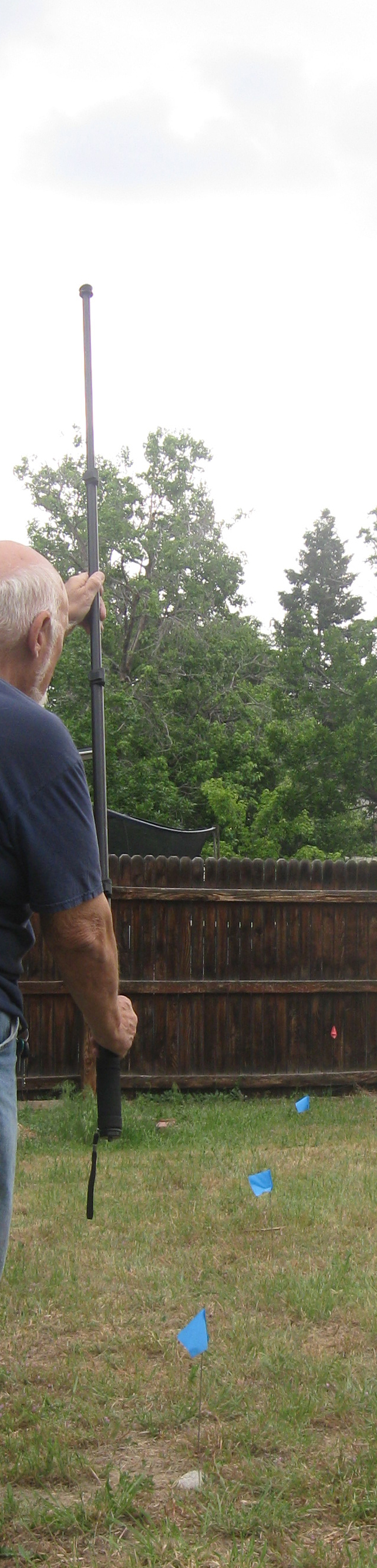
| On June 15 2019 I was
in my back yard making binocular observations. Standing facing north about midway on my north-south line I could clearly see my line of stone markers in the bright moonlight. I was using a monopod with my binoculars. I unmounted the binoculars and extended the monopod to full length. I held the 5 foot rod at arms length in front of me and lined it up with the line of rocks. Looking upward, the tip of the monopod was squarely centered on Polaris. Reenacted here in the daylight, the blue flags marking the location of the north-south stones. |
 |
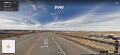
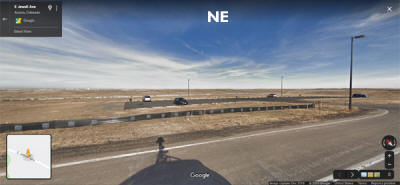
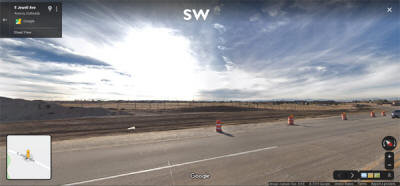
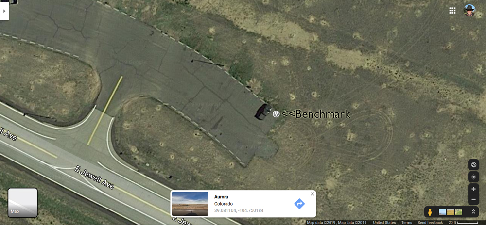
December 10, 2019 -- Finding true North at Buckley Overlook observation point
I have a pretty good view of the sky to the south from my back yard, which is convenient for transit observations, analemma and determining N-S by the shadow method. My east horizon is blocked by my home, and west horizon totally obscured by trees and houses. Measurements of the Sun-Venus angular separation and rising full Moon azimuth and altitude require clear horizons to the East and West. I found a good location about a ten minute drive from home which offers a beautiful 360o unobstructed horizon. There's no signage and it doesn't show up on maps (other than aerial photos). The site is a paved parking area that overlooks the runways for Buckley Air Force base, so I call it "Buckley Overlook". (Ed.note3/25--Google Maps search now lists this as "aircraft viewing"
 |
 |
 |
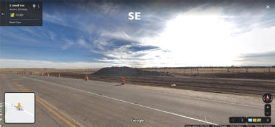 |
Buckley Overlook 39.681004 N, -104.750184 W Elevation 5672' -
1729 M
20301 E Jewell Ave Aurora Colorado
Images from Google Maps--Street View
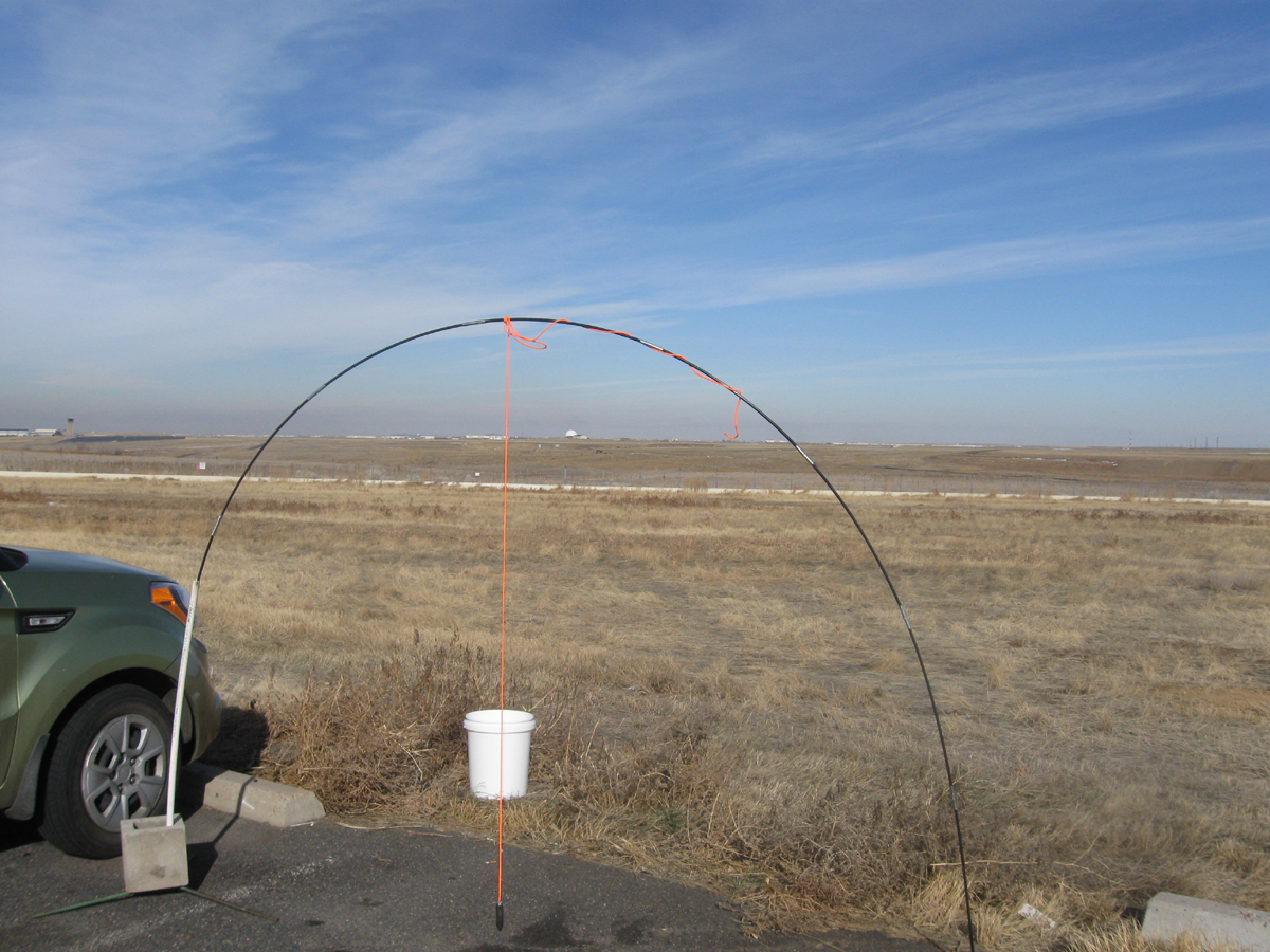
On December 9 2019 I set up an arch about 6' tall using a flexible shock cord
tent pole and cinder blocks. From the top of the arch I suspended a 5 oz.
carpenter's plumb bob on a 1/4" orange nylon cord. Because the shadow of
the plumb line was hard to detect on the pavement and ground growth, I used a
white plastic bucket to see the shadow. I set the bucket about six feet
away from the plumb bob in the general direction of North. For this date
and location Stellarium predicted solar transit at 11:52 am-mst. At this
exact time I lined up the camera so that the shadow of the plumb line
"disappeared" (was occluded by the plumbline itself) on the bucket. At this moment I recorded the
above image.
 |
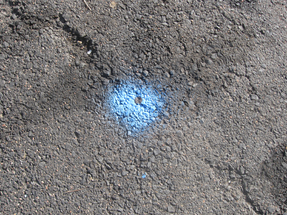 |
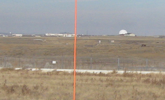
The point where the orange cord crosses the horizon is now my landmark reference point for true north. I set a quarter dollar coin on the ground directly below the plumb bob. After disassembling the arch, I painted over the quarter marker with utility marker spray paint. Using the painted benchmark and the horizon landmark, I now have a true North reference for further observations at this location.
Checking my work
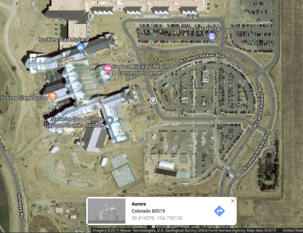
This was an accidental check on my work. It was not until I returned home and began reviewing my images that I noticed a dark smudge on the horizon above and slightly to the West of my true North horizon landmark. A little searching on Google Maps showed the Gaylord Rockies Resort and Convention Center, a multi-story complex 9.75 miles to the North near Denver International Airport. I picked a spot on Google Maps just East of the complex, about where my plumb line would intersect. It showed a longitude of -104.750128, very close to the -104.750184 longitude of my benchmark. On December 12 2019 I returned to Buckley Overlook to make lunar observations. A pair of 7x35 binoculars revealed that the "smudge" on the horizon was indeed the Gaylord resort.
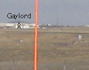 The white structures are located on Buckley AFB. The Gaylord complex is nearly 10 miles away and appears here as a grey shadow above the white buildings. |
 |
-- Return to Astronomy Before
Telescopes page --
Binocrane Home